Maps
Regional Maps | Community Street Map | Community Lot & Block Maps
|
 |
|
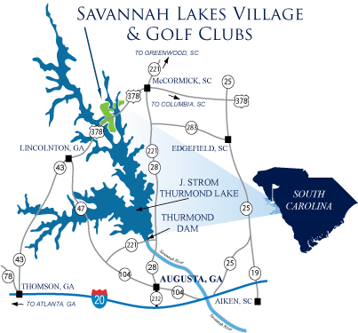
Savannah Lakes Village is located in Western South Carolina, along the state's Freshwater Coast
|
Savannah Lakes Village is in the heart of South Carolina's Freshwater Coast. This region features three lakes linked by the Savannah River, and provides over 150,000 surface ares of water with thousands of campsites and numerous state and federal parks. Lake Hartwell to the north, Lake Russell in the center and Lake Thurmond have turned the South Carolina/Georgia border into a recreational wonderland of water and land sports. Savannah Lakes Village is also surrounded by several unique towns and nearby cities. Four miles to the east of Savannah Lakes Village is the town of McCormick, SC. The quaint and historic main street has been revitalized to reflect the original architecture from the early 1900's. Browse through the antique shops, visit the hardware store founded in 1911, and enjoy your favorite treat from an old fashion 100 year old soda fountain. For additional shopping amenities, the cities of Greenwood, SC and Augusta, GA are only 35 to 45 minutes away.
View Regional Community Map
View Lake Thurmond Recreation Map
* Trouble viewing files? Download the latest free version of Adobe Reader here

|

Autumn Drive on Huguenot Parkway |
Savannah Lakes Village includes over 78 miles of county owned and maintained streets. The network of paved roads are excellent for walking, biking, or driving your golf cart over to the clubs or a friend's house.
Also provided on the map are a few of the walking/biking trails, Historical/Interpretive locations, boat launches and picnic areas provided in the state parks and national forest land bordering Savannah Lakes.
View Community Street Map. The file will open in Adobe Acrobat Reader. Please use the zoom tool to view map details.
* Trouble viewing files? Download the latest free version of Adobe Reader here
Community Lot & Block Maps
|

Strom Thurmond Dam, McCormick, SC |
Savannah Lakes Village consists of six contiguous neighborhoods, which are only separated by streets and the Little River area of Lake Thurmond. Click on the links below to view the lot & block maps. The files will open in Adobe Acrobat Reader. Please use the zoom tool to view details of the map.
*
Trouble viewing files? Download the latest free version of Adobe Reader here
Location Home |
Maps |
Driving Directions